
Dr Elisa Cavatorta completed her PhD in Birkbeck’s Department of Economics, Mathematics and Statistics in 2011.
While the Millenium Development Goals have focused on eradicating extreme poverty and hunger and many efforts have been put in place, food insecurity remains a serious concern in many parts of the world.
The Rome Declaration on World Food Security (1996) and the World Food Summit Plan of Action define food insecurity as the situation when people do not have adequate physical, social or economic access to sufficient, safe and nutritious food which meets their dietary needs and food preferences for an active and healthy life.
Previous studies have tended to consider the factors which affect food insecurity either at household-level (such as income, family structure and sectorial employment); or at district or country level (such as soil fertility depletion, agricultural sustainability and access to markets). While there is a consensus that these factors can be interlinked, they are rarely assessed in combination. One of the main challenges to address environmental factors and accessibility to resources, together with socio-economic characteristics is the integration of the two into a common spatial unit.
Dr Cavatorta and Sam Waples, of Birkbeck’s Department of Geography, Environment and Development Studies, engaged in a interdisciplinary research effort to look at the spatial distribution of food insecurity prevalence among communities in the West Bank region of the Palestinian Territories – an area not only characterised by diverse topography, vegetation, climate and land-use; but one where development and mobility are considerably hindered by the political division of land.
Differently from the existing literature, their study explores the association between household level food insecurity and physical characteristics such as soil fertility and access to resources. A range of data sources are integrated including household level survey data on food insecurity, community level census data as well as environmental factors and resource accessibility data modelled to communities and their surrounds.
The study is part of a larger research project including a similar investigation for the Arab Republic of Syria, which, due to the current events, has been suspended. The case of Syria, a large agricultural producer, would shed light on the role of agriculture in addressing food security.
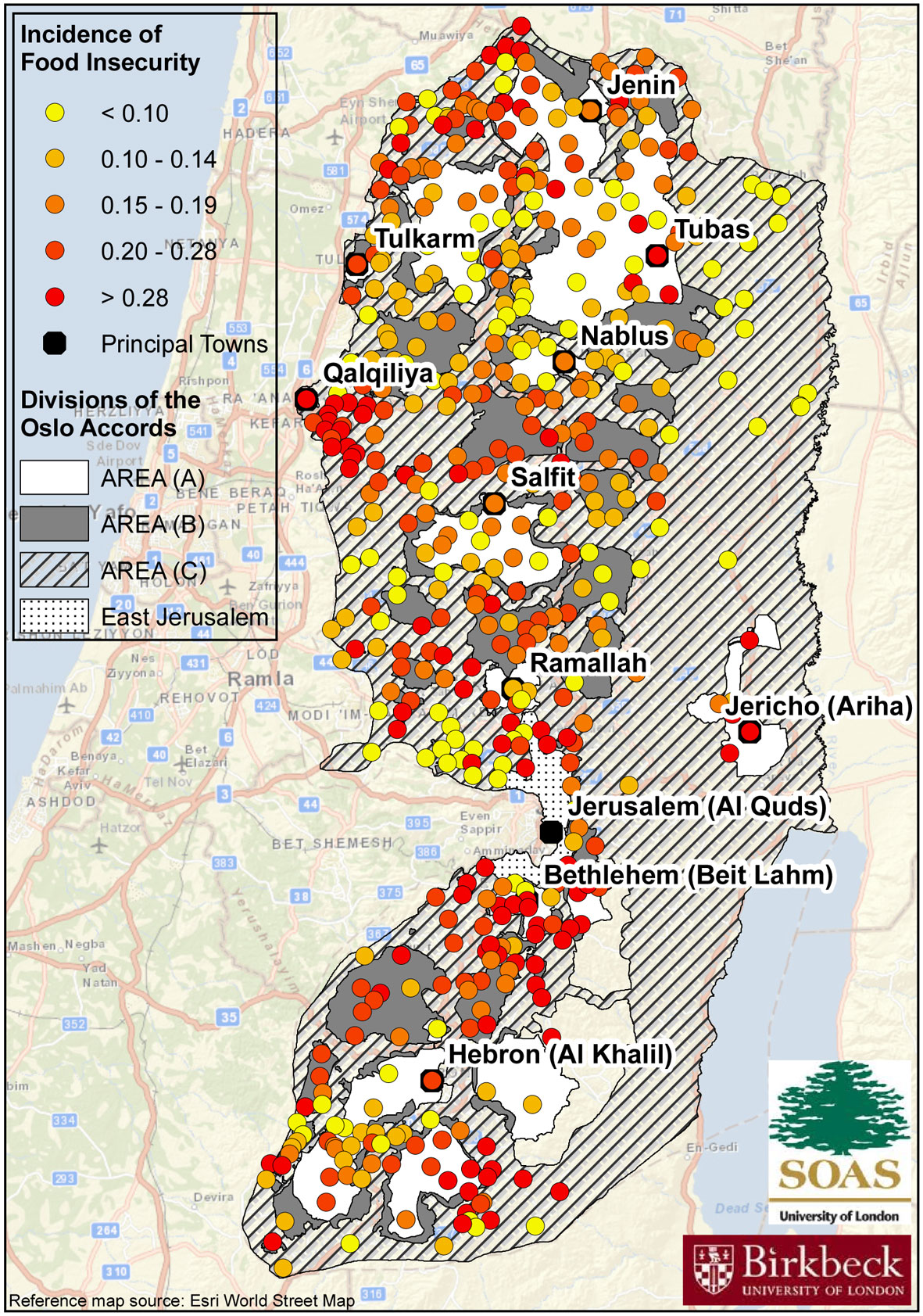
Dr Cavatorta and Sam Waples use a mix of quantitative techniques, fieldwork visits and elaborate Geographic Information System (GIS) information to create an original and comprehensive dataset on 489 communities in the West Bank.
The analysis allowed the estimation of food insecurity incidence at community level throughout the entire West Bank. The results of these estimations were mapped and they highlight distinct spatial patterns, with clusters of severe food insecure communities found in the North West near the border of Israel as well as the centre of West Bank between the towns of Salfit and Bethlehem. The highest levels of food insecurity were found in Area A, the part of the West Bank which falls under Israeli civilian and military jurisdiction.
Dr Cavatorta and Mr Waples elaborated upon existing GIS layers of community and region locations, road networks and mobility restrictions to compute measures of market access, the number of mobility restrictions and measures of access to services. This is a specific consideration to be taken into account in the case of the West Bank, where mobility restrictions have a serious impact on food insecurity levels.
Taking the analysis one step further the results allowed preliminary policy simulations and their impact on food insecurity to be conducted. Amongst the considered policies they simulate improvements in living conditions (increasing wealth or decreasing unemployment), the lifting of mobility restrictions and finally the development of infrastructure. The results indicate that potential policies not only impact upon incidence of food insecurity with varying levels of effectiveness but also the response to policy varies geographically too.
In summary the combination of food insecurity, socio-economic and physical data at the household and community level has created a powerful dataset which has allowed both the prediction of food insecurity in communities not surveyed and how environmental factors explain food insecurity incidence. The results were used to investigate a number of scenarios which highlighted the need for both political stability and effective locally targeted intervention.
